
Preservation and Destruction in the Vale of the White Horse
The Chalk Downs of the Vale of the White Horse have seen many changes since they were eulogised so memorably in ‘Tom Brown’s Schooldays’ in 1857.
In the first chapter Thomas Hughes describes the hone surroundings of the Brown family: ‘most of you have probably travelled down the Great Western Railway as far as Swindon. Those of you who did so with their eyes open have been aware, soon after leaving the Didcot station, of a fine range of chalk hills running parallel with the railway on the left-hand side as you go down and distant scan two or three miles, more or less, from the line.’
 Hughes encouraged his readers to climb to the highest point, Uffington Castle Hill. From here, 900ft above the sea ‘and the boldest, bravest shape for a chalk hill that you ever saw’ could be seen a tremendous view: ‘the ground falls away rapidly on all sides. Was there ever such turf in the whole world? You sink up to your ankles at every step and yet the spring of it is delicious.’ He described the view as he looked down on the great Vale of the White Horse with ‘wave upon wave of the mysterious downs behind’.
Today, as a result of modern agricultural techniques, there are huge arable fields instead of the miles of rolling turf. The plough stirs the flints, which stand out white in the thin, greyish soils. The chalk is composed of myriads of crushed and compacted skeletons and shells of microscopic sea creatures tilted by earth movements into ridges. At the foot of the chalk scarp is a narrow bench of greensand. Where the junction of the porous and less pervious rocks meets, springs gush out and a string of settlements is found from Ashbury to Uffington and Childrey, through Wantage to Blewbury. The underlying rooks have provided the resources and set the limits within which generations of communities have settled and worked.
The landscape of the Vale has been shaped and adapted by the activity of man during the last five thousand years. Neolithic colonists from the European mainland brought with them the skills and equipment of agriculturists: they transported seed corn and domesticated the beasts of their flocks and herds.
It is possible that many of the tribes lived a nomadic life, practising a slash and burn technique in arable cultivation, meeting together on occasions in causewayed camps or for the ceremonial interment of the dead in long barrows. At Stanton Harcourt and Dorchester are the shredded remnants of two of the most important religious landscapes in the country. Where Neolithic mourners used to give vent to their grief and toiled at constructing monuments and barrows for their dead there are now thundering gravel-lorries and huge water-filled pits, a landscape of dereliction.
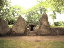 Perhaps the most spectacular Neolithic contribution to the landscape is the Wayland’ s Smithy long barrow on the Ridge Way a mile and a half west of Uffington Castle · Here there was an earthen long barrow, replaced shortly afterwards by a mighty chambered monument using siren megaliths in its construction. The siren facade is dramatically framed by an 18th century beech clump.
The result of the modern ploughing up of the downs has been the virtual obliteration of the network of prehistoric field systems which had been discovered by air photography some forty years ago. The fields of these Bronze and Iron Age farmers are defined in a number of ways. Perhaps the most distinctive and still recognisable form on steep slopes are lynchets. Here the primitive ploughs have cut into the chalk slope on the upper side of the field, and soil wash has built up a bank on the lower. They still survive in a combe about a mile southeast of Uffington Hill, and a splendid series is seen over the Wiltshire boundary at Bishopstone.
It is noteworthy that these early fields are not found in the curving chalk valley which leads down the dip slope to Lambourn. The reason seems to be the portentous presence of a Bronze Age cemetery, the so-called Labour Seven Barrows. As one walks along the road from the Ridge Way the swelling, grass-covered tumuli are seen at the bottom of the slope, between wedges of beech woodland on either flank of the valley. Originally there was a much larger spread of barrows here: 46 in all have been recorded, and they are all visible from the Bronze Age defended site at Rams Hill, which may have acted as a religious focus for the area.
The religious centre hereabouts was the henge monument called in christian times the Devil’s Quoits. The great bank and ditch with its inner ring of standing stones was partly built over by a 1939-45 wartime airfield and has since been quarried away for gravel extraction, another sad example of the destructive erosion of our pre-English heritage.
Since 1983 the Oxford Archaeological Unit excavated a series of barrows which were to be covered by a housing estate, partly for Vietnamese boat people. They recreated the original bowl and disc forms of the barrows by piling the spoil into mounds. But such ‘rescue archaeology’ is a second-best alternative to the preservation of the irreplaceable monuments themselves · It should not have been impossible to integrate aspects of the ancient landscape with the new. Housing estates need open space, which could well have been the area covered by the barrows.
Practically the only features of the prehistoric landscape of the region to have survived modern attempts to flatten them are the hill forts: Alfred’s Castle near Ashdown House, Hardwell above Compton Beauchamp, Uffington Castle, Segsbury and Blewburton Hill.
This was ranching country in those early days, where flocks and herds ranged far and wide and were controlled by horsemen. The importance of the horse to Iron Age society on the downs is indicated by the ceremonial pony burials found in the entrance of the hill fort at Blewburton Hill and, more impressively, by the turf-cut figure of the White Horse at Uffington, a gigantic tribal emblem. For long thought to belong to the Early Iron Age, scholarly opinion now argues with increasing conviction that it is in fact Saxon or Jutish and therefore closely connected with the English Odinist invasion of the fifth century CE. But that is another story.


Leave a Reply
Want to join the discussion?Feel free to contribute!